Ahmed Z. Khan, Philip Stessens
Professor, ahmed.khan@ulb.be, PhD Student
Collaboration: Frank Canters & Frekderik Priem (Cartography and GIS Research Group, VUB); Boud Verbeiren, Willy Bauwens & Charlotte Wirion (Hydrology & Hydraulic Engineering Department, VUB); Ben Somers, Martin Hermy & Jeroen Degerickx (Afdeling Bos, Natuur en Landschap, KULeuven); Frieke Van Coillie, Robert De Wulf & Marie-Leen Verdonck (Department of Forest and Water Management); Sebastian van der Linden & Akpona Okujeni (Geomatics Lab, Humboldt-Universität zu Berlin); Dar Roberts, Joe McFadden & Erin Wetherley (Department of Geography, UCSB, USA); Bino Maiheu & Hans Hooyberghs (Unit Environmental Modelling, VITO)
Keywords: Ecosystem Services, Planning, Urban Design, Sustainability
UrbanEARS: Urban Ecosystem Analysis supported by Remote Sensing
Urbanisation and global warming present enormous challenges for our cities. Green space is increasingly being converted to densely built-up environments that are vulnerable to heat and water stress. At the same time extreme meteorological events are becoming more common and intense. Sustainable development and scientifically supported management of urban areas are crucial to protect our quality of life in the city. Most policy support tools and environmental models are however not adapted to the spatial complexity of urban landscapes. Using environmental data provided by remote sensing can help us in overcoming this knowledge gap.
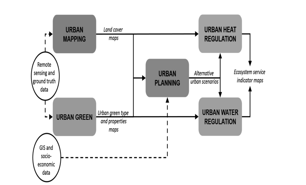
In UrbanEARS we explore the potential of state-of-the-art remote sensing technologies for detailed, spatially explicit characterization of the urban environment. Investigated data sources include imaging spectroscopy, multispectral remote sensing and laser altimetry. Acquired information on the characteristics of green and built-up areas is subsequently used to improve the parametrization of urban biophysical models. As such, we strive at improving the operational value of urban ecosystem services related to temperature and water regulation.
Within the URBAN MAPPING and URBAN GREEN parts, the team aims to map and characterize the urban environment based on recent remote sensing technologies. The focus is on the integration of multi- and hyperspectral imagery with airborne LiDAR and on the development of generic workflows which can easily be transfered to other sensors and locations. The produced land cover and urban green maps are subsequently used in the URBAN HEAT AND WATER REGULATION parts for the enhanced parameterisation of urban biophysical models. These models in turn result in ecosystem service indicator maps related to temperature and runoff reduction. Using a variety of GIS and socio-economic data in combination with an agent-based modelling approach, different realistic urban growth scenarios are produced in the URBAN PLANNING part. These different scenarios are evaluated with regard to their impact on the urban climate and water cycle using the aforementioned models. Based on this research, valuable guidelines related to sustainable urban development will be formulated for urban planners and managers.
BATir Chair for Sustainable Architecture & Urbanism (SAU) is the main partner for the work package on developing alternative urban planning scenarios, and their testing and calibration, including contribution to the work on Urban Heat Island. The Scenarios work’s aim is to develop a simulation framework to assess the impact of future residential and economic development within the Brussels metropolitan area on heat-related and hydrological behavior. Within this framework, SAU and the CGIS of VUB define different urban planning scenarios, corresponding to contrasting views on future urban development, and assess their relative impacts on urban ecosystem services.
Research Objectives
– Explore the potential of innovative remote sensing approaches for improved land cover parameterisation of urban biophysical models
– Examine the use of spectral and LiDAR remote sensing data for characterising chemical and structural properties of urban vegetation
– Consolidate chemical and structural properties of the urban environment, derived by remote sensing, by defining a local climate zone (LCZ) typology that is far better suited to characterise urban climatic conditions than traditional land cover datasets typically employed for urban climate modelling.
– Develop a quantitative ecosystem service mapping tool on urban water regulation making optimal use of the detailed, high-resolution remote sensing based characterisation of the urban ecosystem.
– Develop a simulation framework for assessing impacts of urban growth and alternative urban planning scenarios on urban heat and water regulation, based on an integration of agent-based modelling of human activities at neighborhood level, and grid-based, remote sensing supported modelling of biophysical processes.
Project partners:
– Division Forest, Nature & Landscape, KULeuven
– Department of Geography Vrije Universiteit Brussel
– Department of Hydrology, Vrije Universiteit Brussel
– Laboratory of Forest Management, University of Ghent
– Geography Department, Humboldt-Universität zu Berlin, Germany
– Department of Geography, University of California Santa Barbara, US
– Environmental Modeling Unit, Flemish Institute for Technological Research, Mol
– Building, Architecture and Town Planning Department, Université Libre de Bruxelles
The project is funded by the Belgian Science Policy Office within the RESEARCH PROGRAMME FOR EARTH OBSERVATION – “STEREO III”